One step at a time!!
This was an academic project where we were asked to create an interactive system that solves a transpiration and mobility issue that suffers from a severe design issue within Westwood, a West Los Angeles neighborhood. Focusing on an experience and interactions for a particular demographic that will solve, serve, and delight.
Santa Monica College
IxD Studio 1
Team
Kris Bumford
Francis Laura Palacio
Lana Pak
Hawa Camara
Year
Fall 2022
Role
UX / UI Design
Concept Design
User Interview & Testing
Research
Illustrator
Prototyping

Get 2 Steppin’
A way-finding app that tackles sidewalk
congestion for pedestrian through community
and city participation.
Branding by Lana Park with Illustrations by Kris Bumford
Problem
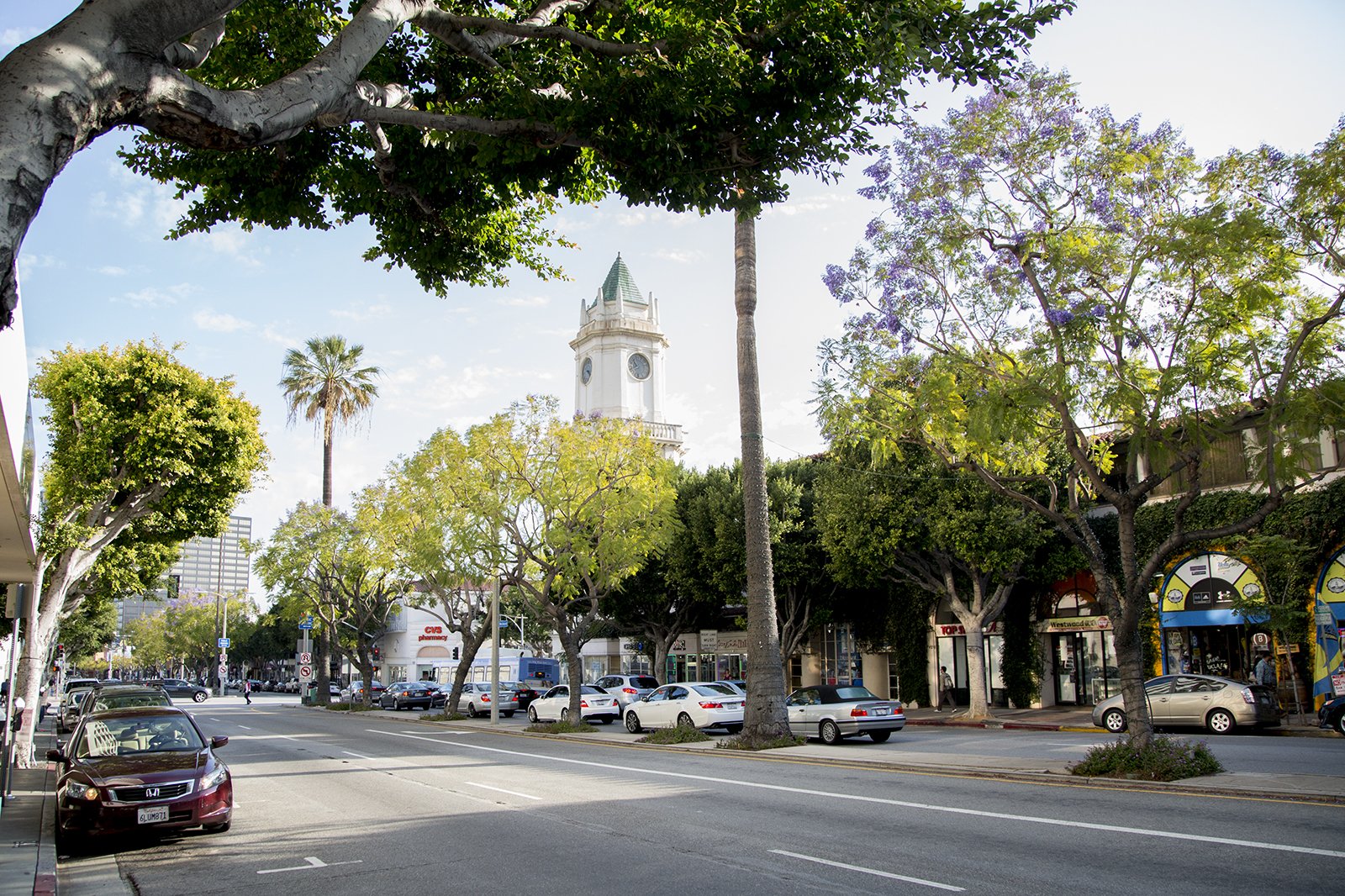
Westwood was developed in the 1920s to be a location for shopping, dining, and entertainment. But most notably, its know for being the home of UCLA schools and hospitals. However, getting around Westwood is extremely chaotic with so much going on. It's has become a hub for bus routes, ride shares, commuters and soon to be Metro station. Making sidewalks extremely congested to navigate during peak hours.
Insight
During our interview, research, and onsite observations, we found that navigate the sidewalks in Westwood is difficult to navigate due to overcrowding, events, hazards, and sidewalk closers. Making pedestrians taking risky behaviors to circumvent the these pain points in order for them not to be late to their commitments. With Westwoods demographic being majority students, we wanted to focus on them and find a way to help them be on time and make safer choices while getting around Westwood.
Solution
Get 2 Steppin' is a gamified wayfinding experience that rewards participation by giving savings to local business in Westwood. Giving users the opportunity to navigate around Westwood confidently, notify others in the community and city about hazards, and discover businesses that could enrich students experience while walking around Westwood.
The Challenge
How might we help UCLA students avoid sidewalk obstructions so they can get to their destination in a safe and timely manner?
Observations
We started our process with observations of the Westwood area. We got to witness and experience a lot of the head aches that many visitors and residents experience. We found ourselves in crowds with UCLA students, hospital staff, ride-shares, and shoppers. As well as, being overwhelmed with the amount of cars and buses on the street.
As we continued we found that navigating Westwood personally very frustrating. We noticed construction projects, maintenance, and good old-fashioned Mother Nature giving us many unsafe walking paths, which create unexpected backtracking.
We could see issues getting around Westwood a challenge especially if you're new to area or have accessibility issues.

Congestion in front of Starbucks.

Blockage causing pedestrians to walk in the street to get around.

Broken sidewalks creating accessibility issues.
Research & Interviews
Once we finished our observations we did research and interviews around Westwood. Our initial findings found that Westwood has an average population density of 32,624 people per square mile. That's more than the City of Los Angeles with an Avg. 17,406 people per sq. mile. Making it one of the most densely populated area in Los Angles County. We also found that around 21% of Angelenos walk 1 kilometer to get to work or school. Telling us that we need to focus our attention on UCLA student or healthcare worker. But our focus got more narrow when we discovered that majority of Westwoods population is between the ages of 18 to 29 years old, making them most likely college students. Informing us that we need to make this demographic the attention for our solution.
David - UCLA Student
Most of the time, when I run into construction or anything blocking my way, I have to walk into the street to get around it or turn around and find a new direction. I also run across the street to get to the other side if there is a lot of construction. It's really frustrating and annoying.

Magaly - UCLA Alumni
“My favorite mode of transportation at UCLA was definitely walking, and there was a lot of students walking. It was also nice to experience the college environment.”

Sofia - UCLA Alumni
Westwood is very walkable, but it’s not that safe, it has lots of people, so it’s really congested, and has more homeless than I originally thought.


E-scooter riders using the sidewalks because they didn’t feel safe on streets.
Getting to buses were difficult due to crowded sidewalks
Unexpected sidewalk closers would cause backtracking and walking in to the street to get around those closers.
Damage sidewalks made accessibility an issue for individuals with mobility problems.
Unhoused sleeping on sidewalks
We conducted around 20 interviews, majority during Westwoods Farmers Market. We heard a lot of pain points about buses, e-scooters, sidewalks, parking, and safety in regards to the unhoused. But what we found is that sidewalks was a common theme with students.

Lana Pak interviewing UCLA student during Westwood Farmers Market.
Recruiter, interview script, and study provided by Hawa Camara


On research days we wear black and hide our faces. Lana Pak and Francis Laura Palacio providing insight.
Solution
Get 2 Steppin' is a way finding app that helps UCLA students in Westwood navigate the sidewalks more easily. The app allows users to report, view, and clear hazards on the sidewalks in a fun gamified way that rewards participation with saving to local businesses. It also helps them find the quickest and safest route to their destination, using the perspective of the sidewalk, instead of streets, like most way finding apps. Giving students a more enjoyable, enriching, and safe walking experience in Westwood
Navigate around Westwood confidently while making areas more accessible.

Notify others in the community as well as the city about potential hazards

Discover businesses and leisure spots that could enrich the walking experience.

Low-fidelity Prototype
We went through 2 iterations of Low-fidelity prototypes. Our first stage was a cardboard prototype to introduce ourselves to the idea of creating a way finding app and to get our hands working on a physical artifact instead of relying on digital in order to spark inspiration. Thorough with method we found that iconography and illustration would be a fun way to help with the gamification of our solution.
Low- fidelity prototype for Get 2 Steppin’ by Kris Bumford
Our second iteration we migrated our cardboard prototype to the digital and created what we felt would be an intuitive experience.

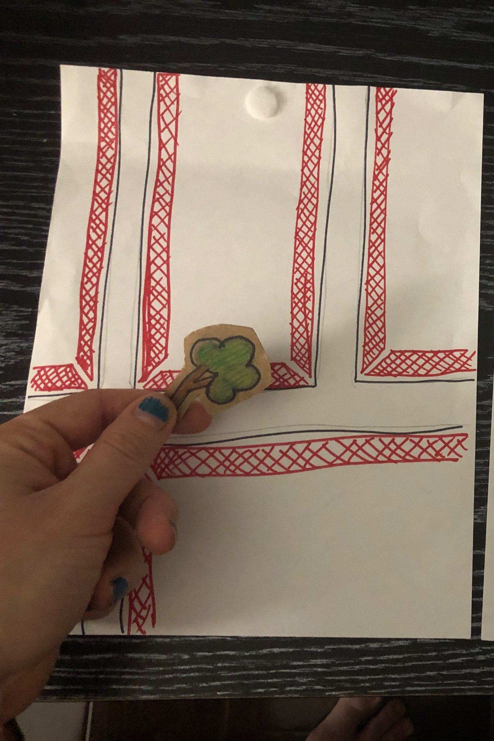
Hazard report required placing the picture at the location.
Cardboard prototype created by Kris Bumford. Wireframe by Francis Laura Palacio and Lana Pak.


Homepage would show hazards in your area.
User testing insights
& Outcomes
With our user testing it showed us that some of our ideas didn't translate over to a new user and wasn't intuitive.
We found that our recruits had problems understanding the iconography.
finding street information wasn't intuitive.
placing hazards had to many steps and was asking a lot of the user.
had problems understand how to clear a hazard.
With that feedback we implemented onboarding to Get 2 Steppin'. This part of the app will clear up any confusion of what the app is about and how to use it. It explained the reporting and clearing of hazards, as well as defining the iconography they will see on the app.
We gave the neighborhood and street profile more touch points throughout the app. Primarily on the home page next to the avatar as well as in the search bar, since many user went to those locations for this information.
Finally we did away with selecting the sidewalk during reporting and went with GPS location system. GPS has proven accurate within 16 ft, taking out the extra work for our users.
Gamification
We wanted to gamify the Get 2 Steppin experience to incentivize students and encourage friendly competition. In order to get the students to be involved and want to participate we created personalization and rewards to Get 2 Steppin’.
Personalization
We to give students the opportunity to express themselves with avatars. And since the experience is focused on walking in their neighborhood we felt shoes were the fun way to do that.
Illustration and avatar selection prototype by Kris Bumford
Rewards
As users contribute to the experience, they’ll be given badges and titles alongside coupons to the local business so they’ll be able to save where they play and showing secret gems in neighborhood they might not have known about.


Illustration by Kris Bumford and badges by Francis Laura Palacio
Results
Scripted and filmed: Kris Bumford, Francis Laura Palacio, and Lana Pak Editing: Francis Laura Palacio Screen grabs: Lana Pak
Narrator: Francis Laura Palacio Simon: Kris Bumford Jianna: Lisa Veta
Navigation
The Home Screen shows the hazards in your general area and clicking on each individual icon will show the type of hazard along with any information about that particular hazard.
Avatar is displayed at the bottom left corner, right above the navigation. And next to it you’ll find a quick access point to neighborhood and street information. Showing the names of the neighborhood you're currently in, along with the street. Another access point is in the search bar, allowing the user to use whatever is easiest to them.
Clearing Hazards & Rewards

When students press on an icon it will display relative information regarding that hazard. Showing time reported and the number of people that have declared that the hazard is clear.
Once three students say that the hazard is clear. They will be given a badge for certain milestones, like the “Westwood Warrior” badge seen here. It’s awarded when a students report 50 hazards. Along with badge students will be given coupons to local business. Giving them the opportunity to save along with exploring more of Westwood.
Hazard Reporting

When students report hazards the iconography and colors will be identical to what they see on the home screen. Helping them quickly associate the colors with those hazards. Helping them make quicker and knowledgable decision with longer use.
Students will have another way of submitting hazards through the resource link on the page. The link will direct them off the app and on to website that will provide them with individual and numbers to call for more urgent or sensitive matters. We found that the unhoused was a concern with a lot of our interviews, but we felt having them them on the home screen with the rest of the hazards was insensitive and needed to be handled with more care.
Once the picture for the hazard has been submitted it will be geo tagged to the location. And a prompt will show thanking the student and informing them that the information submitted will be given to the appropriate people to be cleared up.
Neighborhood & Street Info

Neighborhood and street information mirror each other in set up but show different information. Neighborhood shows a more macro look while street shows a more micro look, focusing on individual streets. Students can see current hazards and its status of being either “Resolved” or “Active”
Students will also see when the most active times are in their area
They will also be able to discover local coffee, parks, and shopping. In order to enrich their walk.

Connecting with Community & City
Students can see the location of all hazards reported on the map. Street information will show micro view of the same information.
They will see a list of all hazards with street address and reported date.
Pressing on a hazard will take them to chat / statues feature with the city. That way students can hold the city accountable to fix problems in the city.
We wanted everything to clear and intuitive for students when they start using the Get 2 Steppin’. Creating an onboarding part of the experience helps clarify and confusion we initially saw in the beginning of our user testing.
Onboarding

Reflection
When we decided to look into Westwood as our location from this project, I got really excited. I knew it had a lot to offer in terms of point of views and mobility options. But after our initial observations and interview we were bogged down with to many options, some being way to big for our team to execute within the timeline, so we needed to slim down and think more micro. Thankfully with continued research and interviews, it gave us the clarity and focus we needed to identify our user and a problem. I gained a new appreciation for the research and interview process.
Looking back on the project I wish we spent more time interviewing business and shop owners in Westwood. Seeing how our solution offered saving to local businesses it would have been great to gain more of their perspective on the needs of walking within Westwood. As well as to how Get 2 Steppin could help with local business besides directing students to their stores and offering quick savings. I would also like to spend more time finding ways on how to gamify the experience.
This project was a great learning experience. I worked with an amazing group of designers. And I'm excited to build off of the experiences that we had during this project, like setting early expectations and having a methods of accountability.
Get 2 Steppin'
〰️
Interactive Prototype
〰️
Get 2 Steppin' 〰️ Interactive Prototype 〰️
Thank you
for sticking with me
~~
Thank you for sticking with me ~~